
Most people associate Dunster with the rather splendid castle, together with the well-preserved medieval village which sits beneath it, or the yarn market. The castle and village, together with many other manors in Somerset, were owned by the de Mohuns from the time of the Norman Conquest until 1405 and thereafter by the Luttrell family, who possessed it until 1976. The castle was built on a hill, or tor, called Dunna’s Torre in around AD 700; Dunna was a Saxon thane who had constructed a timber framed fortress on the site of the present castle (which sadly has no traces left of the original Norman stronghold). It is thought that Dunna’s legacy is the name of the village, castle and surrounding area (Lamacraft, 2013; Coates & Webb, 2017). There was, however, also an important haven harbour, also called Dunster, about a mile from the village, possibly from Saxon times or even earlier (Concannon, 1995),until the seventeenth century. It is even possible there was also an earlier harbour much closer to the castle than the haven by the beach. Dunster Haven was situated in Blue Anchor Bay on the Somerset coast.
The weir or haven harbour was similar to many others of this type on the Somerset coast, including Minehead and Porlock Weir. Gilman (1999) stated that those at Porlock Weir and Dunster were in existence over a thousand years ago.
Grahame Farr declared in 1954 that he was unable to find any visual evidence or trace of the site of Dunster Haven on his travels along the Somerset coast, partly due to the River Avill, the feeder stream at Dunster, having changed its course since the harbour was in existence. Strangely, he did not mention the Hawn, the word being a corruption of ‘haven’. The Hawn is now a large fresh water pond just behind the beach, which both Concannon (1995) and Gilman (1999) assert is the vestige of the sea port, and was likely to have been the largest of the Somerset haven harbours before the river moved and the creek silted up. Day and Masters’ map of 1782, which can be seen in the Somerset Heritage Centre, shows the Avill further west than it is today, flowing from its most northerly point in a south easterly direction towards the sea, with a widening pill (creek) and small estuary, and then, at the river’s mouth, a clear approach channel through the offshore sand and pebbles heading in a northerly direction until it reaches the Nap Lock ridge. A spit of land northeast of the river is what now constitutes Dunster Beach and the Hawn is what remains after the harbour mouth silted up.

Ashford (2017) reports that fishing boats were recorded at Dunster in 1317 and states that the harbour was first mentioned in records in 1321, with ‘diverse weirs on the sea’ in 1331. However, Concannon (1995) writes that the earliest record of the harbour was in the twelfth century, in a charter mentioning Mersh Lane and the North Pulle (pill) flowing through Fowler’s Marsh. Marsh Street, a settlement separated from Dunster village by the A39 road, is still there; it, and Lower and Upper Marsh Farms lie on the flat alluvial plain between Dunster and the sea. This area, as the names suggest, has long been prone to flooding; indeed, a flood relief channel was constructed in 1969 and the Avill now flows into this and then out to sea at the eastern end of the beach. The original river bed still carries water and, after meandering around Dunster Warren and Marsh, goes under the West Somerset Railway line near the station and then out to sea through the shingle via a pipe (Allen, 1978).
In 1183 a portreeve (a port warden analogous to a harbourmaster) was fined for keeping the proceeds of illegally imported corn. Concannon (1995) also mentions a charter of 1254 in which Henry III granted ‘The Hawn’ to Reginald de Mohun in 1254.
Concannon (1995) postulates there may have been a jetty or quay further inland and therefore further up the creek than the Hawn. The harbour mainly served the needs of the castle and the growing medieval village, so being closer to the main area of habitation would obviously have been advantageous. Anchor chains found near the A39, which is roughly half way between the castle and the sea, during ploughing may be an indication of such a landing place.
Trade and vessels
There is a general consensus that Dunster Haven’s harbour was, at one time, second only to that of Bridgwater in terms of size, and presumably trade, but due to it going out of use and trade transferring to Minehead when the new quay was constructed there in the 1600s there are few records.
Fishing would have been an important activity to feed the residents of Dunster, including the monks of the Benedictine Priory established before 1090. Although some of these fish were caught using sea-going vessels, weirs, a form of fish traps, using the outgoing tides were also used (Kelly, 2014). Ashford (2017) describes corn being purchased in the Dunster area in 1338, and then shipped to Scotland for a military campaign, almost undoubtedly by the de Mohun in residence at the time. Spanish, Gascon and Italian merchants were also known to be trading in that year; the only other port in Somerset in which they could do so was Bridgwater (Concannon, 1995). Woollen cloths made in the area were also an export item.

Thomas Carter, a boat owning merchant, was trading in the 1370s and 1380s. The Mary of Dunster was a casualty of war; she was one of 39 vessels captured in 1375, during the Hundred Years War, near the mouth of the River Loire. Depending on which record is accurate she was either of 75 or 57 tons burthen (Concannon, 1995) and she and her cargo were valued at £275. The ship was built of oak from the castle park, indicative of ship building at Dunster. Around this time weirage duties were collected to maintain the Haven.
In the early 1400s Richard Horton traded goods at Dunster and Sir Hugh Luttrell (the Luttrells had acquired the castle in 1374) bought live cattle in Wales and had them salted down in Dunster, presumably to provide food for the castle. In 1405 15 ‘flaggons’ of olive oil arrived in Dunster via Bristol (Ashford, 2017) and ten years later a cargo of books were brought there, also from Bristol. Gilman (1999) stated that Dunster saw the export of equipment for Henry V’s campaign against France in the Hundred Years War; for example, the Leonard of ‘Dunsterre’ left to go to war with the French in 1418. She underwent a refit at Dunster, which is further evidence of ship building, prior to the expedition and returned from her voyage with a cargo of Bordeaux wine! The sale of this booty was sufficient to almost cover the cost of the enterprise (Concannon, 1995). Sir Hugh Luttrell and his retinue were fighting in France and vessels sailed regularly from Dunster to keep them supplied with salted fish, live and preserved cattle, and mutton and beer.
Sir Hugh was also engaged in ‘home improvements’ at the castle and in 1419 stone from Bristol was brought to Watchet and then transhipped to Dunster and in 1426 ten thousand Cornish stone slates were also brought to the Haven by sea (Concannon, 1995; Ashford, 2017); presumably Sir Hugh was at the roof building phase by then. It is known there was a lime kiln at Dunster in 1427, for which coal from Wales would have been needed (Ashford, 2017). In 1484 a new fish weir, next to the sea in Avill Manor, was built and some of the catch may have been salted and exported.
From 1558, when Minehead’s townspeople had been granted a charter to enable them to control the port of Minehead they charged weirage duties for vessels going to Dunster Haven, much to the disgust of the then resident of Dunster Castle. From this time on, the trade in and out of Dunster diminished; even in 1559 Dunster was described as “not fytt nor mete to charge nor discharge” in a survey prepared for the Exchequer regarding landing places in Somerset other than Minehead or Bridgwater (Concannon, 1995). Dunster Haven, Watchet and Porlock Bay were listed as ‘sub’ ports of Bridgwater in 1565; the three together were described as importing salt, wine, victuals, wood and coal in small boats. A year later the Mychael of ‘Donstare’ carried 200 stones of wool exported from Milford in Wales. The Luttrells, accepting that Dunster Haven was no longer viable as a port due to silting up, built a new quay and harbour at Minehead which was completed in 1616. It replaced the old Minehead harbour which was also becoming blocked up with pebbles, and which the residents of the town could not afford to maintain; the end result was that Minehead lost its charter and the Luttrells regained control.
Dunster Haven continued to function as a small harbour probably for another hundred and fifty years or so; Gerard, in 1633, rather disparagingly described the harbour as ‘pretty’ and being often visited by shipping going to and from Ireland. Other vessels, such as the Gift of Swansea, paid keelage to Minehead in the 1640s, whilst on route to Dunster (Concannon, 1995). However, by the late 1700s no vessels of note were going there. It is not known when the river mouth became totally choked with sand, pebbles and vegetation but the Hawn was described, as the ‘Hone,’ in the nineteenth century.
Tourism
There is little tourism related to Dunster Haven per se, the beach and Hawn having been left in their natural states for more than a hundred years (Concannon, 1995). Most visitors, then and now, explore the castle and medieval village instead. However, following the successful introduction of bathing huts at Minehead and Blue Anchor early in the twentieth century and the progression to chalets, in which one could stay overnight, at Blue Anchor a few years
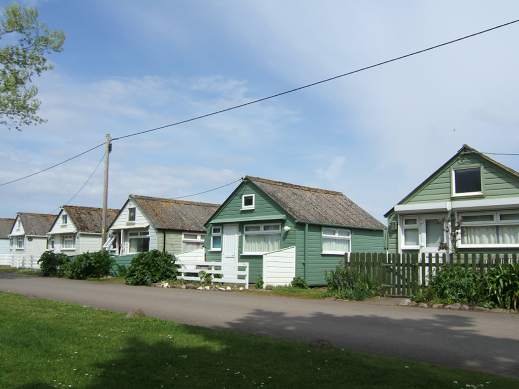
later, Alexander Luttrell decided to develop beach chalets at Dunster Beach as a commercial enterprise. The first one was erected in 1927, and screened by trees, therefore well out of view of the residents in the castle. It was also painted green to blend in with the environment. The hut still exists today and is chalet number 17 (Concannon, 1995). More huts were constructed, initially being mere shells with no internal features. Owners were able to adapt their chalets to meet their own needs, adding partitions and shelving, for instance. Toilet blocks with flush lavatories were provided and eventually electricity too.

At the beginning of World War Two the chalets at Dunster housed evacuees and later the Army requisitioned them, removing all internal fixtures and fittings, which were stored in Minehead. Dunster Beach became Dunster Camp and the chalets were used to house soldiers of the Royal Engineers and the Somerset Light Infantry while they built sea defences; tangible evidence of some of these, namely pill boxes, remain on the beach and its environs. Other Army units came and went as the war progressed. The Beach was returned to Mr Geoffrey Luttrell in 1946 and the chalets returned to their owners, albeit in a somewhat sorry state (Concannon, 1995). The holiday camp was sold in 1951 to Herbert Kempton Reeves, who attempted to ‘improve’ the Hawn and provide access to the sea for small boats. The costs proved prohibitive and Mr Reeves’ dream did not come to fruition. He also searched for evidence of a medieval landing stage or quay to no avail. On a positive note more huts were built and services, such as the provision of shops, improved. In 1965 the owners of the chalets formed a company called Dunster Beach Holidays Ltd. and purchased the foreshore and beach as well as all the chalets and other buildings and machinery. They have also tried to purchase the Hawn, which is Crown land and leased, but had not succeeded, according to Concannon, by 1995. There is public access to the beach and the Hawn.
There are now 265 chalets at Dunster Beach, all of which are painted green, albeit in different shades, the beach itself, which is excellent for collecting driftwood and has good views across to Wales and around Blue Anchor Bay. The heritage West Somerset Railway has a station on Dunster Marsh; the line runs just behind the beach and steam trains run regularly in summer. There is also, of course, the Hawn, which is now a tranquil place and a haven for nature instead of ships, around which a gentle stroll is warranted.

All photographs by Maggie Watkinson
References
Allen, N V (1978) The Waters of Exmoor: Microstudies E2. The Exmoor Press, Dulverton, Somerset.
Ashford, P (2017) A Somerset Mercantile Commentary: The Customs District of Bridgwater 1320-1500. In: Webb, A J (Ed), (2017). A Maritime History of Somerset. Volume Three. Somerset Archaeology and Natural History Society.
Coates, R and Webb, A (2017) Somerset’s Maritime Place-Names. In: Webb, A J (Ed), (2017). A Maritime History of Somerset. Volume Three. Somerset Archaeology and Natural History Society.
Concannon, B (1995). The History of Dunster Beach. Monkspath Books.
Farr, G (1954). Somerset Harbours including the Port of Bristol. Christopher Johnson, London
Gerard T (1633) The Particular Description of the County of Somerset.
Gilman, J (1999). Exmoor’s Maritime Heritage. Exmoor Books, Dulverton, Somerset.
Kelly, B (2014) Sea Fishing in Somerset: Past, Present and Future. In: Webb, A J (Ed), (2014). A Maritime History of Somerset. Volume Two. Somerset Archaeology and Natural History Society.
Lamacraft, G. (2013) A Brief History of Dunster. Self Published, Dunster.
Somerset Record Society (1981) Somerset maps: Day and Masters, 1782; Greenwood, 1822. Introduction by J.B. Harley and R.W. Dunning, Vol. 76.
The most comprehensive book about Dunster Beach and the Hawn is that by Bernard Concannon.
Websites
https://dunsterbeachholidays.co.uk/
Maggie Watkinson, July 2021